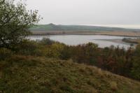
Šibeničník
General Characteristics
County (administration):
Jihomoravský kraj
District (town):
Břeclav
Village:
Mikulov
Cadastre:
Mikulov na Moravě
Map sheets:
34-14 Mikulov, 34-142 Mikulov
Accessibility:
no traffic restriction ( by car)
ID:
673
Geology
Short characteristics of the site:
Prominent landmark, elevation formed of the Upper Jurassic Klentnice Beds and Ernstbrunn Limestone. Klentnice Beds (Oxfordian up to Lower Tithonian) consist of dark calcareous claystones overlain by limestones rich ih micro- and macrofauna. Overlying Ernstbrunn Limestone consist of brecciated clayey limestones. Stratigraphically and geomophologically interesting locality.
Regional geologic unit:
Carpathians > Klippen Zone > Klippen Zone
Stratigraphy:
Jurassic, Upper Badenian
Subject:
geomorphology, geology, stratigraphy, paleontology
Geological phenomenon:
rock, fault
Genesis:
sedimentary
Rock:
limestone, clay, sand
Territorial protection
Level of protection:
Nature reserve in Protected landscape area
Part of LEPA (Large-size especially protected areas):
Pálava
Additional information:
See the Digital register of the Agency for Nature Conservation and Landscape Protection of the Czech Republic AOPK ČR, code 434 (Šibeničník)
Conflicts of interests:
waste disposal
References
- Čtyroký, P. et al. (1985): Základní geologická mapa 1:25 000, list 34-142 Mikulov. - ČGÚ Praha.
- Čtyroký, P. et al. (1990):Vysvětlivky k základní geologické mapě 1:25 000 a vysvětlivky, list 34-142 Mikulov. - ČGÚ Praha.
Elaboration and Updating
Elaborated by:
Zdeněk Stráník, 29.11.1993
Updated by:
Novotný Roman, 28.10.2012
Citation
The database Important geological localities of the Czech Republic: 673 [online]. Prague: Czech Geological Survey, 1998 [cit. 2023-06-16]. Available from: https:// lokality.geology.cz/673.
Location in map:
Assessment
Scientifical assesment:
great
Educational assesment:
major
Significance:
national
Representativeness:
major
Geological importance:
significant study profile, geo-historical value, geo-regional value (mapping)
Locality conditions:
acceptable
You can send information about a change in the status of the site to lokality@geology.cz


