Čertovy skály u Aše
General Characteristics
County (administration):
Karlovarský kraj
District (town):
Cheb
Village:
Podhradí
Cadastre:
Podhradí u Aše
Map sheets:
11-11 Aš, 11-114 Aš
Accessibility:
passable footpath
ID:
4447
Geology
Short characteristics of the site:
THIS DATABASE RECORD IS BEING CURRENTLY TRANSLATED
Regional geologic unit:
Bohemian Massif > Bohemian Massif - crystalline complex and pre-Variscian Palaeozoic;
Bohemian Massif > Saxothuringicum
Stratigraphy:
Paleozoic
Subject:
geology, geomorphology, quaternary geology, structural geology
Geological phenomenon:
characteristic rock, deformation fabrics, erosion
Genesis:
metamorphic (general metamorphism), frost weathering
Rock:
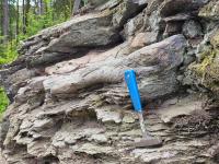
mica schist
Territorial protection
Level of protection:
Registered geological localities suggested for protection
Part of national geopark:
Egeria
Conflicts of interests:
sports
References
- Škvor Vladimír (1975): Geologie české části Krušných hor a Smrčin. Knihovna Ústředního ústavu geologického. Praha: Academia
- Rojík Petr (2016): Geologie a nerostné zdroje Karlovarského kraje. ISBN 8088017254
- webová stránka www.CertovySkalyAs.cz (autor Zdeněk Nepustil)
Elaboration and Updating
Elaborated by:
Petr Rojík, 17.12.2025
Updated by:
Citation
The database Important geological localities of the Czech Republic: 4447 [online]. Prague: Czech Geological Survey, 1998 [cit. 2023-06-16]. Available from: https:// lokality.geology.cz/4447.
Location in map:
Assessment
Scientifical assesment:
medium
Educational assesment:
major
Significance:
regional
Representativeness:
major
Geological importance:
geo-regional value (mapping), geoturistic value
Excursion locality:
yes
Locality conditions:
acceptable
You can send information about a change in the status of the site to lokality@geology.cz