Horušice
General Characteristics
County (administration):
Středočeský kraj
District (town):
Kutná Hora
Village:
Horušice
Cadastre:
Horušice
Map sheets:
13-41 Čáslav, 13-411 Chvaletice
Accessibility:
passable footpath
ID:
4397
Geology
Short characteristics of the site:
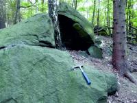
An outcrop of amphibolitized gabbro, one of the largest bodies along the margin of the Chvaletice Massif. Cambro-Ordovician in age (488 ± 2 Ma), it forms small boulder-rich exposures. The rock is typically dark green, medium- to coarse-grained, and composed mainly of actinolite, magnesiohornblende, and plagioclase.
Regional geologic unit:
Bohemian Massif > Bohemicum > Magmatites in Bohemicum > -Chvaletice Massif
Stratigraphy:
Paleozoic
Subject:
geology
Geological phenomenon:
intrusion
Genesis:
magmatic
Rock:
gabbro
Territorial protection
Level of protection:
Registered interesting geological localities
Conflicts of interests:
without conflicts
References
- Buriánek ed. (2026). Vysvětlivky k základní geologické mapě České republiky 1:25 000, list 13-411. Chvaletice. Praha: Česká geologická služba.
Elaboration and Updating
Elaborated by:
David Buriánek, 15.07.2024
Updated by:
Citation
The database Important geological localities of the Czech Republic: 4397 [online]. Prague: Czech Geological Survey, 1998 [cit. 2023-06-16]. Available from: https:// lokality.geology.cz/4397.
Location in map:
Assessment
Scientifical assesment:
medium
Educational assesment:
major
Significance:
regional
Representativeness:
major
Geological importance:
geo-regional value (mapping)
Locality conditions:
no problems
You can send information about a change in the status of the site to lokality@geology.cz