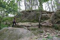
Vacov, opuštěný lom
General Characteristics
County (administration):
Jihočeský kraj
District (town):
Prachatice
Village:
Vacov
Cadastre:
Miřetice u Vacova
Map sheets:
22-34 Vimperk, 22-341 Vacov
Accessibility:
no traffic restriction ( by car)
Technical object:
quarry
ID:
4236
Geology
Short characteristics of the site:
A small abandoned quarry situated about 400 m from the southeast. the edge of Vacov and reveals a migmatized biotite paragnaiss, a characteristic rock of the Šumava Moldanubian. It is the most common rock in the region, but there are not many nice and especially easily accessible outcrops, moreover, you can drive almost to the locality. The wall quarry, situated in a small draw, has a size of about 20 x 20 m, the wall is stepped, a total of about 7 m high. The quarry used to be overgrown and used as an occasional landfill, but it was cleaned and arranged with the surroundings for leisure activities, for example, there are benches by well-trodden paths. The rock is a slightly weathered dark brown-gray, finely grained biotite paragneiss. It is markedly foiled, indistinctly banded, rather smudge-shaped, sometimes wrinkled into decimeter folds. It consists of plagioclase, quartz and potassium feldspar with a content of 10-20% brown biotite. The felts of the feldspar stand out from the rock, sometimes merged into light, rather discontinuous strips, a sign of migmatization, ie weak melting. at an angle of 30 °. Two dominant subvertical fracture systems are evident in the quarry, characteristic of outcrops in the widest surroundings. The east-west fracture system (198/90) is repeated with a frequency of dm to meters, according to this system the veins of syenite porphyry were also intruded, which do not occur in the vicinity of the quarry, but are widely documented on the whole map sheet. The second fracture system has an approximately perpendicular, north-south direction (80/90). The rock has a low magnetic susceptibility in the range of 0.20–0.43 x 10⁻³ SI, caused by biotite and accessory ilmenite and indicating the absence of magnetite. The contents of natural radioactive elements (average of 3 measurements) correspond to the usual contents for the similar rocks: K = 3.1%, eU = 5.1 ppm, eTh = 12.6 ppm.
Regional geologic unit:
Bohemian Massif > Moldanubicum > Metamorphic units in Moldanubicum > Moldanubicum of Šumava and South Bohemia
Stratigraphy:
Proterozoic - Paleozoic
Subject:
petrology
Geological phenomenon:
horizontal section, characteristic rock
Genesis:
metamorphic (general metamorphism)
Rock:
paragneiss
Territorial protection
Level of protection:
Registered interesting geological localities
Conflicts of interests:
without conflicts, waste disposal
References
- Žáček, V. et al. (2021): Vysvětlivky k základní geologické mapě České republiky 22-341, list Vacov. - Archiv České geologické služby, Praha.
Elaboration and Updating
Elaborated by:
Vladimír Žáček, 23.01.2021
Updated by:
Citation
The database Important geological localities of the Czech Republic: 4236 [online]. Prague: Czech Geological Survey, 1998 [cit. 2023-06-16]. Available from: https:// lokality.geology.cz/4236.
Location in map:
Assessment
Scientifical assesment:
minor
Educational assesment:
minor
Significance:
regional
Representativeness:
major
Geological importance:
geo-regional value (mapping)
Locality conditions:
no problems
You can send information about a change in the status of the site to lokality@geology.cz


