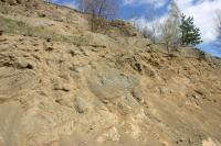
Krásný vrch
General Characteristics
County (administration):
Karlovarský kraj
District (town):
Karlovy Vary
Village:
Hroznětín
Cadastre:
Hroznětín
Map sheets:
11-21 Karlovy Vary, 11-212 Ostrov,11-214 Karlovy Vary
Accessibility:
entry permit for car necessary
Technical object:
quarry
ID:
4094
Geology
Short characteristics of the site:
Abandoned quarry exposing Tertiary volcanites. Tuff cone was formed by phreatomagmatic extrusion of Surtsey type. Tuff body was later cut by basanite dykes and larger bodies. Fractures in the basanite are covered by calcite and aragonite. The basement is formed by kaolinized granite. This locality is planned to be protected.
Regional geologic unit:
Bohemian Massif > Tertiary > Basins under Krušné hory Mts.and adjoining volcanic uplands
Stratigraphy:
Neogene
Subject:
volcanology, mineralogy
Geological phenomenon:
unconformity, cinder cone, dyke, intrusion, mineral
Genesis:
volcanic
Rock:
basalt, lapillistone
Territorial protection
Level of protection:
Registered geological localities suggested for protection
Part of national geopark:
Egeria
Conflicts of interests:
exploitation
References
- Magna T., Rapprich V. (2017): Basalt 2017 Kadaň: Abstracts and Excursion Guide.Czech Geological Society, Czech Geological Survey, 110 str.
Elaboration and Updating
Elaborated by:
Vladislav Rapprich, 09.05.2017
Updated by:
Kukal Zdeněk, 19.02.2018, Kukal Zdeněk, 22.02.2018, Vajskebrová Markéta, 30.06.2021
Citation
The database Important geological localities of the Czech Republic: 4094 [online]. Prague: Czech Geological Survey, 1998 [cit. 2023-06-16]. Available from: https:// lokality.geology.cz/4094.
Location in map:
Assessment
Scientifical assesment:
great
Educational assesment:
major
Significance:
international
Representativeness:
major
Geological importance:
significant study profile, geo-regional value (mapping), geoturistic value
Excursion locality:
yes
Locality conditions:
no problems
You can send information about a change in the status of the site to lokality@geology.cz


