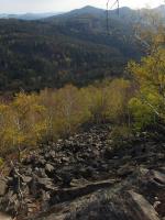
Malý Stožec
General Characteristics
County (administration):
Ústecký kraj
District (town):
Děčín
Village:
Rybniště
Cadastre:
Rybniště
Map sheets:
02-24 Nový Bor, 02-242 D.Podluží
Accessibility:
passable footpath
ID:
1917
Geology
Short characteristics of the site:
A ridge formed by a Tertiary phonolite dyke exhumed from Cretaceous sediments. Thickly columnar jointing and specific magmatic structures. Slopes are covered by blocky talus.
Regional geologic unit:
Bohemian Massif > Tertiary > Tertiary - scaterred relics of alkaline Volcanics
Stratigraphy:
Tertiary
Subject:
sedimentology, stratigraphy, geomorphology, petrology
Geological phenomenon:
block field, stony organ, dyke, frost cliff, rock bag
Genesis:
volcanic , frost weathering
Rock:
phonolite
Territorial protection
Level of protection:
Interesting geological localities in Protected landscape area
Part of LEPA (Large-size especially protected areas):
Lužické hory
Conflicts of interests:
without conflicts
References
- Valečka J. a kolektiv autorů, 2000: Vysvětlivky k základní geologické mapě ČR v měřítku 1 : 25 000 list 02242 Dolní Podluží.- Český geologický ústav Praha.
Elaboration and Updating
Elaborated by:
Jaroslav Valečka, 31.12.2000
Updated by:
Plíšek Antonín, 18.01.2005, Vajskebrová Markéta, 22.04.2020
Citation
The database Important geological localities of the Czech Republic: 1917 [online]. Prague: Czech Geological Survey, 1998 [cit. 2023-06-16]. Available from: https:// lokality.geology.cz/1917.
Location in map:
Assessment
Scientifical assesment:
medium
Educational assesment:
middle
Significance:
supraregional
Representativeness:
major
Geological importance:
geoturistic value
Locality conditions:
no problems
You can send information about a change in the status of the site to lokality@geology.cz


