Jeroným - Čistá
General Characteristics
County (administration):
Karlovarský kraj
District (town):
Sokolov
Village:
Rovná
Cadastre:
Čistá u Rovné
Map sheets:
11-23 Sokolov, 11-233 Rovná
Accessibility:
no traffic restriction ( by car)
Technical object:
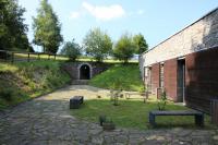
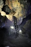
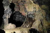
old mine workings
ID:
1268
Geology
Short characteristics of the site:
Tin ore deposit. This depoisit was formed at a contact between a granite of Čistá type and surrounding gneisses. Granites suffered a series of postmagmatic changes. Two types of mineralization were defined, impregnation type and vein type. Instructive locality showing a history of mining. Petrologically and mineralogically very important.
Regional geologic unit:
Bohemian Massif > Saxothuringicum > Krušné hory Mts. (Erzgebirge) Pluton
Stratigraphy:
Devonian - Permian
Subject:
mining and mining impacts, economic geology
Geological phenomenon:
ore mineralization
Genesis:
hydrothermal mineralization, magmatic, anthropogenic (anthropogenic activity)
Rock:
granite, greisen
Territorial protection
Level of protection:
Technical or cultural monument
Part of LEPA (Large-size especially protected areas):
Slavkovský les
Part of national geopark:
Egeria
Conflicts of interests:
without conflicts
References
- Kůrková, I., Žáček, V., Landa D.-A., Rozkošný, I., Vylita, T. (2026): Slavkovský les – Zrození vody z kamene. – Čes. geol. služba. Praha.Táborský Z., 1997: Challenges to chemical geology ´97. - Field Trip Guide, 1997, str. 24 - 25, ČGÚ. Praha.
Elaboration and Updating
Elaborated by:
Jiřina Dašková, 23.11.2001
Updated by:
Mlčoch Bedřich, 07.10.2009, Gürtlerová Pavla, 01.08.2010
Citation
The database Important geological localities of the Czech Republic: 1268 [online]. Prague: Czech Geological Survey, 1998 [cit. 2023-06-16]. Available from: https:// lokality.geology.cz/1268.
Location in map:
Assessment
Scientifical assesment:
great
Educational assesment:
major
Significance:
national
Representativeness:
major
Geological importance:
significant study profile, geo-historical value, geo-regional value (mapping), geoturistic value
Excursion locality:
yes
Locality conditions:
no problems
You can send information about a change in the status of the site to lokality@geology.cz