General Characteristics
County (administration): Olomouc Region
District (town): Jeseník
Cadastre: Zlaté Hory
Map 1 : 50 000 (sheet No): 1513, 15131
Geological region: Silesicum and Žulová massif
Accessibility: - entry permit for car necessary
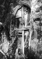
Technical object: mine, gallery
ID : 862
Geology
Short characteristics of the site: Old mine with preserved adit entrance. Disseminated Fe-Cu ores in schists and metaquartzites of the Vrbno Group. Interesting example of medieval methods of mining.
Regional geologic unit: Bohemian Massif - crystalline complex and pre-Variscian Palaeozoic - Moravosilesian region - Silezicum
Stratigraphy: paleozoikum - devon
Subject: mining and mining impacts, economic geology
Geological phenomenon: ore mineralization
Genesis: anthropogenic (anthropogenic activity)
Rock: slate, schist, qurtzite
Territorial conservation
Level of protection: Technical or cultural monument
Protection of a geol. phenomenon: A - Protected Area (declared as Geological Locality)
Conflicts of interests: reclamation
References
Večeřa, J. (1991): Taponomie dolů ve Zlatých Horách. In.: Historie dolování ve Slezsku a na severní Moravě. Zlaté Hory. Zachař, Z. (1991): Současný stav hornických děl ve Zlatých Horách. In.: Historie dolování ve Slezsku a na severní Moravě. Zlaté Hory.Večeřa, J.; Večeřová, V. (2010): Historie zlatohorských dolů (History of mining in Zlaté Hory). – PINKA, 98 s. Jeseník Elaboration and Updating
Elaborated by: Večeřa Josef, 24.11.93
Updated by: Večeřa Josef 07.04.11, Kukal Zdeněk 07.12.17, Vajskebrová Markéta 12.02.18 Citation
The database Significant geological localities of the Czech Republic: 862 [online]. Prague: Czech Geological Survey, 1998 [cit. 2024-04-29]. Available from: http:// lokality.geology.cz/862. Location in map:
Links to neighbouring localities within 2 km radius are available on mouse click in the map window. | 


![[ENG]](img/vlajka-cr.gif)

![[legenda]](images/legenda.jpg "legenda k mapě ZABAGED")