General Characteristics
County (administration): Zlín Region
District (town): Kroměříž
Cadastre: Kurovice
Map 1 : 50 000 (sheet No): 2531, 25313
Geological region: Fore-Magura, Rača (E from the Napajedla gateway), Bystrica & Bílé Karpaty units
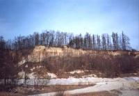
Technical object: guarry
ID : 690
Geology
Short characteristics of the site: Active quarry with outcrops of deluvial and eolian sediments, fossil soils and soil complexes. These units vertically alternate. Four climatic and sedimentary cycles have been identified.
Regional geologic unit: Carpathian - West Carpathiqan Quaternary - Quaternary of Eastern Carpathian deposition areas
Stratigraphy: kenozoikum - kvartér
Subject: geology, petrology, sedimentology, quaternary geology, paleontology
Geological phenomenon: fosil soil
Genesis: sedimentary
Rock: colluvium, loess, soil, topsoil
Territorial conservation
Level of protection: Registered interesting geological localities
Protection of a geol. phenomenon: C - Geological phenomenon is the reason for a registration in the database of CGS
Conflicts of interests: open cast mining, private property
References
Kovanda, J. - Smolíková, L. - Fejfar, O. (1982): Erforschung des Basalteils einer pleisrozanen Schichtenfloge am Hang der Kurovice-Klippe (Mittelmahren). - Anropozoikum, 14, 29-55. Praha. Elaboration and Updating
Elaborated by: Uhlířová Ivana, 29.11.93
Citation
The database Significant geological localities of the Czech Republic: 690 [online]. Prague: Czech Geological Survey, 1998 [cit. 2024-04-29]. Available from: http:// lokality.geology.cz/690. Location in map:
Links to neighbouring localities within 2 km radius are available on mouse click in the map window. | 


![[ENG]](img/vlajka-cr.gif)

![[legenda]](images/legenda.jpg "legenda k mapě ZABAGED")