General Characteristics
County (administration): Hradec Králové Region
District (town): Jičín
Cadastre: Doubravice
Map 1 : 50 000 (sheet No): 0343, 03431
Geological region: Permo-Carboniferous of the Krkonoše-piedmont and Lower Silesian basins
Accessibility: - entry permit for car necessary
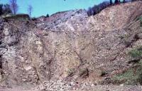
Technical object: guarry
Excursion locality: yes
ID : 276
Geology
Short characteristics of the site: A large quarry at the road between Doubravice and Kyje villages. Irregulary interbedded massive and amygdaloidic andesitoide (possibly three lava flows) with a layer of redbrown siltstone and mudstone in the eastern part of the quarry. They are locally well bedded micaceous, with greenish mottling. They contain irregular andesitic clasts (lapilli, volcanic bombs). Also similar sediments underlying andesite body have some layers with pyroclastic admixture (coarse tuffs to tuffaceous agglomerates). Andesite of the locality belongs to the Kozákov andesite body, laying approx. at the boundary of Vrchlabí and Prosečné Formation (Autunian).
Regional geologic unit: Bohemian Massif - superficial deposits and post-Variscian magmatites - Upper Carboniferous and Permian - Permocarboniferous Volcanits
Stratigraphy: paleozoikum - perm
Subject: mineralogy, geology
Geological phenomenon: lava flow, slickenside, bedding, characteristic rock
Genesis: volcanic , sedimentary
Rock: melaphyre, claystone, siltstone
Territorial conservation
Level of protection: Registered geological localities suggested for protection
Protection of a geol. phenomenon: B - Geological phenomenon is the reason for a recommendation to the protection
Part of the Geopark: Bohemian Paradise
Conflicts of interests: without conflicts, open cast mining
References
Gotthardt J./1933/: Petrografická povaha podkrkonošských melafyrů.-APPVČ,18,2,65 p.Praha. Polák J./1923/: Drahokamy našeho kraje.-SbOJKT,II,1,p.24-26,4,108-110.-Turnov. Ziegler V./1977/: Geologické poměry chráněné krajinné oblasti Český ráj.-Bohemia centralis,6,p.7-42.Praha. Ziegler V./MS/: Geologické zajímavosti Českého ráje.-Pečky.; Schovánková D. (1989): Petrologie mladopaleozoických vulkanitů podkrkonošské pánve. - Část 5. Permské bazaltandezity. - MS Archiv Čes. geol. úst. Praha.; Stárková M., Rapprich V., Breitkreuz C. (2011a): Variable eruptive styles in an ancient monogenetic volcanic field: examples from the Permian Levín Volcanic Field (Krkonoše Piedmont Basin, Bohemian Massif). Journal of Geosciences 56, 2, 163-180. ISSN 1802-6222. DOI 10.3190/geosci.095.; Stárková M., Adamová M., Burda J., Čáp P., Drábková J., Dvořák I., Grygar R., Holásek O., Hroch T., Kycl P., Krupička J., Pécskay Z., Rapprich V., Rýda K., Řídkošil T., Skácelová Z., Šimůnek Z., Šebesta J., Tasáryová Z., Zajíc J. (2011b): Vysvětlivky k základni geologické mapě ČR 1 : 25 000 03-431 list Lomnice nad Popelkou. Závěrečná zpráva, 190 s. MS archiv ČGS. Elaboration and Updating
Elaborated by: Ziegler Václav, 11.11.93
Updated by: Prouza Vladimír 15.05.03, Šimůnek Zbyněk 24.09.09, Stárková Marcela 15.11.11 Citation
The database Significant geological localities of the Czech Republic: 276 [online]. Prague: Czech Geological Survey, 1998 [cit. 2024-04-20]. Available from: http:// lokality.geology.cz/276. Location in map:
Links to neighbouring localities within 2 km radius are available on mouse click in the map window. | |


![[ENG]](img/vlajka-cr.gif)


![[legenda]](images/legenda.jpg "legenda k mapě ZABAGED")