General Characteristics
County (administration): Capital City of Prague
District (town): Praha
Cadastre: Hlubočepy
Map 1 : 50 000 (sheet No): 1242, 12421
Geological region: Prague agglomeration
Accessibility: - passable footpath
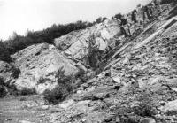
Technical object: guarry
ID : 226
Geology
Short characteristics of the site: Abandoned quarry exposes the Třebotov and Choteč limestones in their typical development. The boundary interval Dalejan/Eifelian is well visible. Paleontologically and stratigraphically very important locality.
Regional geologic unit: Bohemian Massif - crystalline complex and pre-Variscian Palaeozoic - Bohemicum (Central Bohemian region) - Barrandien
Stratigraphy: paleozoikum - devon - spodní devon - ems - dalej (svrchní ems), paleozoikum - devon - střední devon - eifel
Subject: stratigraphy, paleontology, lithology, geology, structural geology
Geological phenomenon: fossils fauna, bed, outcrop
Genesis: sedimentary
Rock: limestone
Territorial conservation
Level of protection: Nature monument
Additional information: See the Digital register of the Agency for Nature Conservation and Landscape Protection of the Czech Republic AOPK ČR
Protection of a geol. phenomenon: A - Protected Area (declared as Geological Locality)
Part of the Geopark: Barrandien
Conflicts of interests: vegetation
References
Barrande, J. (1865): Défense des colonies. III. Étude générale sur nos étages G - H avec application spéciale aux environs de Hlubočep, prés Prague. 1-367. Prague. Bouček, B. (1941): Geologické výlety do okolí pražského. - Melantrich, 202 p. Praha. Chlupáč, I. (1959): Faciální vývoj a biostratigrafie břidlic dalejských a vápenců hlubočepských (eifel) ve středočeském devonu. - Sbor. Ústř. Úst. geol., odd. geol., 25 (1958), 445-511. Praha. Chlupáč, I. (1988): Devon. in: Cháb J.: Vysvětlivky k základní geologické mapě ČSSR 1:25 000 12-421, Praha-jih, Ústř. Úst. geol., 34-44. Praha. Elaboration and Updating
Elaborated by: Chlupáč Ivo, 14.04.93
Updated by: Steinová Marika 16.09.09, Steinová Marika 23.11.09, Vajskebrová Markéta 18.01.19 Citation
The database Significant geological localities of the Czech Republic: 226 [online]. Prague: Czech Geological Survey, 1998 [cit. 2024-04-19]. Available from: http:// lokality.geology.cz/226. Location in map:
Links to neighbouring localities within 2 km radius are available on mouse click in the map window. | |


![[ENG]](img/vlajka-cr.gif)


![[legenda]](images/legenda.jpg "legenda k mapě ZABAGED")